Medellín’s Mountain Maze: What No One Tells You Before You Go
Nestled in Colombia’s Andes, Medellín dazzles with its spring-like weather and vibrant culture. But its dramatic terrain? That’s a whole other story. Rolling between steep hills and deep valleys, the city’s layout can turn a dream trip into a logistical puzzle. I learned this the hard way—what looked like a 15-minute walk on the map took me over an hour. This is your real talk guide to navigating Medellín’s unique landscape without the frustration. What most travel blogs gloss over, this article reveals: the mountainous reality behind the postcard-perfect views. From deceptive distances to elevation surprises, here’s how to truly prepare for a city that doesn’t just sit on hills—it lives on them.
The Allure of Medellín: More Than Just a City in the Mountains
Medellín has transformed over the past three decades from a city once shadowed by turmoil into a celebrated model of urban innovation and cultural revival. Known as the "City of Eternal Spring" for its remarkably stable climate—averaging between 22°C and 25°C (72°F to 77°F) year-round—it draws visitors seeking warmth without scorching heat. But beyond its pleasant weather and renowned hospitality lies a deeper charm: a city that has reinvented itself through creativity, infrastructure, and resilience. Its public spaces, street art, and festivals reflect a community proud of its progress, and travelers often speak of a tangible sense of optimism in the air.
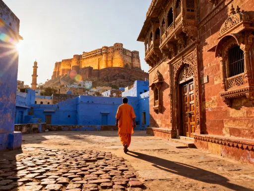
Yet, one of Medellín’s most defining features remains under-discussed in travel guides: its geography. The city stretches along the Aburrá Valley, a narrow, elongated basin flanked by the towering slopes of the Andes. This natural corridor is only about 60 kilometers long and 6 to 10 kilometers wide, forcing urban development to expand vertically as much as horizontally. As a result, neighborhoods cascade up the mountainsides like layers of a terraced garden, each level offering new vistas and micro-environments. From above, the city resembles a living mosaic, with red-tiled roofs, lush greenery, and winding roads tracing the contours of the hills.
This verticality isn’t just scenic—it shapes every aspect of life in Medellín. Elevation influences temperature, air quality, and even access to services. A short journey from one barrio to another can mean descending 200 meters or more, a shift that affects both physical effort and weather conditions. For visitors, this means the city cannot be experienced like a typical flat urban destination. Walking from point A to point B isn’t a matter of distance alone; it’s a negotiation with gravity. Understanding this early allows travelers to adjust expectations and plan more effectively, turning potential frustration into appreciation for the city’s dynamic character.
Understanding Medellín’s Topography: Why “Flat” Doesn’t Exist Here
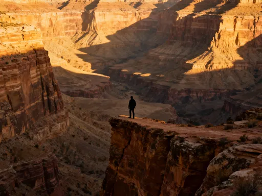
To truly grasp Medellín’s complexity, one must first understand its topography. The city occupies a section of the Central Cordillera of the Andes, one of three major mountain ranges running through Colombia. This region is defined by abrupt elevation changes, deep ravines, and unstable soils—conditions that challenge conventional city planning. Medellín spans approximately 380 square kilometers, but much of that area is steep, with inclines often exceeding 30 degrees. The city center sits at around 1,400 meters above sea level, but surrounding neighborhoods climb rapidly, with some residential zones reaching over 2,000 meters—comparable to cities like Denver, Colorado.
What this means for travelers is that the concept of “flat” walking simply does not apply. Even streets that appear level on a map can have subtle but persistent inclines that accumulate over distance. A 1-kilometer walk in Medellín can feel more like a 3-kilometer hike elsewhere due to constant uphill progression. This is particularly true in areas like El Poblado, Laureles, and San Javier, where roads follow the natural slope of the land rather than being engineered for ease of movement. Visitors accustomed to grid-based cities may find themselves unexpectedly winded after what seemed like a short stroll.
The terrain also creates microclimates—small zones with distinct weather patterns due to elevation and exposure. One neighborhood might be bathed in sunlight while another, just a few blocks uphill, is shrouded in mist. Rain can fall heavily in the higher zones while the valley floor remains dry. This variability means travelers should always be prepared for changing conditions, especially when moving between elevations. Smart planning includes checking the forecast for specific areas, not just the city as a whole. Understanding that Medellín’s geography is not just scenic but functional helps visitors respect its demands and appreciate its ingenuity.
The Hidden Hike: How Daily Commutes Become Climbs
Many travelers arrive in Medellín unprepared for the physical reality of its streets. A common scenario: booking a charming Airbnb advertised as “5 minutes from the metro,” only to discover that the final stretch involves a relentless uphill climb on narrow, uneven sidewalks. This experience is not an exception—it’s the norm in much of the city. What looks like a brief walk on a digital map can easily become a 20- to 30-minute ascent, especially when carrying luggage, shopping bags, or a day’s worth of fatigue. The lack of elevation data on standard navigation apps compounds the issue, leaving visitors misled by distance alone.
Areas like El Poblado, often recommended for tourists due to its restaurants and boutique shops, are particularly deceptive. While the commercial center around Parque Lleras is relatively accessible, many accommodations are located on side streets that climb sharply into the hills. Similarly, neighborhoods like Envigado and Las Palmas offer stunning views but require significant effort to reach on foot. Even locals, accustomed to the terrain, often opt for taxis or motorbikes for short trips that appear trivial on paper. For visitors, this means that physical stamina becomes a key factor in daily planning.
One traveler recounted her experience staying in a highly rated guesthouse near the Universidad de Medellín. The listing showed proximity to public transit, but the final 400-meter stretch involved a 60-meter elevation gain—equivalent to climbing a 20-story building. After a long day of sightseeing, the return journey felt nearly impossible. Another visitor described using Google Maps to walk to a popular café, only to spend 45 minutes climbing a steep, poorly lit street with no handrails. These stories are not outliers; they reflect a widespread gap in travel information.
The solution lies in awareness and preparation. Travelers should assume that any route involving hillside neighborhoods will require physical effort. Checking topographic maps or using apps with elevation profiles can provide a more accurate picture. Wearing supportive footwear is essential—sandals or flat shoes without arch support can lead to discomfort or injury. Pacing is equally important: taking breaks, hydrating frequently, and avoiding midday heat can prevent exhaustion. By treating every walk as a potential hike, visitors can better manage their energy and enjoy the city without unnecessary strain.
Transportation Tricks and Traps: When the Metro Doesn’t Go Far Enough
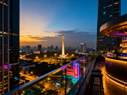
Medellín’s public transportation system is widely praised as one of the most innovative in Latin America. The backbone of this network is the Medellín Metro, a clean, efficient, and affordable rapid transit line that runs north to south through the valley. Complementing it is the Metrocable—a series of aerial gondolas that connect hillside communities to the metro stations. These cable cars were originally built to improve access for underserved populations, but they have also become a unique and scenic way for visitors to navigate the city’s vertical landscape.
However, even this advanced system has limitations. While the metro and Metrocable lines cover major corridors, they do not reach every neighborhood. The final leg of a journey—often referred to as the “last mile”—frequently requires walking, and in Medellín, that walk can be steep and poorly maintained. Taxis and ride-sharing apps like Uber and Didi help bridge this gap, but availability can vary, and prices may rise during peak hours or bad weather. Some drivers are reluctant to enter narrow residential streets, leaving passengers to walk the remainder—a challenge when already fatigued.
One of the most notable examples of infrastructure addressing topographical challenges is the outdoor escalator in Comuna 13. This 384-meter-long series of electric stairs was installed to replace a grueling footpath and has since become a symbol of urban inclusion. While it is now a popular stop on guided tours, its primary function remains practical: enabling residents to move safely and efficiently between elevation levels. Visitors using this route should respect its purpose and avoid blocking the flow during busy times.
To navigate transportation effectively, travelers should adopt a hybrid approach. Plan metro or Metrocable rides for longer distances along the valley, then use ride apps for the final ascent or descent. Always confirm drop-off points with drivers—some may stop at the base of a hill, assuming passengers will walk up. For evening travel, avoid scheduling late returns to hillside accommodations; darkness, combined with steep terrain, increases risk and discomfort. Download offline maps and save key addresses in Spanish to show drivers. With thoughtful planning, Medellín’s transport network can be both reliable and rewarding.
Choosing the Right Neighborhood: Location Is Everything—Literally
Selecting where to stay in Medellín is one of the most critical decisions a traveler can make—and it goes far beyond aesthetics or amenities. In a city defined by elevation, location determines not just convenience but physical accessibility. A hotel described as “central” may still require a strenuous climb if it’s situated on a high ridge. Conversely, a slightly more peripheral location on flatter ground can offer greater ease of movement and less daily fatigue.
Laureles Central is often recommended for first-time visitors, and for good reason. This neighborhood sits on relatively level terrain near the middle of the valley, making it walkable and well-connected by metro and bus. It offers a balanced mix of local life and tourist-friendly services, with cafes, parks, and shops within easy reach. El Poblado, while popular, is more fragmented—its commercial core is accessible, but many accommodations are scattered up steep side streets. Travelers seeking comfort and convenience may find themselves trading views for exertion.
Other areas like Envigado and Sabaneta, located in the southern part of the metro area, offer quieter environments and more residential charm but require greater reliance on vehicles for mobility. Northern zones like Belén or San Javier are served by the metro but include steep connecting roads. For those drawn to scenic beauty, neighborhoods like El Retiro or Las Palmas deliver breathtaking panoramas, but access is primarily by car, and walking options are limited.
The key is to prioritize accessibility without sacrificing experience. When booking accommodations, look for properties near metro stations or on major avenues with flatter approaches. Use topographic maps or elevation tools to assess the surrounding terrain—many booking platforms now integrate this data. Read recent guest reviews with attention to comments about walking difficulty, taxi access, and safety at night. Consider staying in multiple locations if planning an extended visit—one base for urban exploration, another for mountain immersion. By aligning lodging choices with physical realities, travelers can maximize enjoyment and minimize strain.
Packing and Planning: Gear Up for a City That Climbs Back
Preparing for Medellín requires more than just a passport and itinerary—it demands thoughtful packing and physical readiness. The city’s terrain turns everyday movement into a form of low-intensity hiking, so appropriate gear is essential. Footwear tops the list: sturdy, broken-in walking shoes with good traction and ankle support are non-negotiable. Avoid sandals, flip-flops, or smooth-soled shoes, especially if planning to explore beyond the main plazas. Moisture-wicking socks can prevent blisters, and trekking poles—while uncommon for tourists—can be helpful for those with joint issues or limited mobility.
Clothing should be lightweight and breathable, suited to mild temperatures but adaptable to sudden changes. Mornings and evenings can be cool, especially at higher elevations, so a light jacket or fleece is advisable. Rain is frequent in Medellín, with two main rainy seasons (April–May and October–November), so a compact, waterproof layer is a smart addition. Umbrellas are less practical on narrow sidewalks or windy hills, so a packable raincoat or poncho is preferable. A small backpack with a water bottle holder allows for hands-free movement and easy access to essentials.
Physical preparation can make a significant difference, particularly for travelers unaccustomed to inclines. Engaging in low-impact cardio—such as brisk walking, stair climbing, or cycling—in the weeks before the trip can build endurance. Strengthening leg muscles through squats, lunges, or hiking improves stability on uneven terrain. Even simple daily stair use instead of elevators can help condition the body. Once in Medellín, start with shorter walks and gradually increase distance and elevation to allow for acclimatization.
Planning tools are equally important. Use Google Maps with the terrain view enabled to visualize elevation changes. Save offline maps in case of spotty connectivity. Check walking routes in advance, paying attention to street names and landmarks. Apps like Komoot or AllTrails can provide elevation profiles for more detailed analysis. Hydration is critical—carry water at all times, as dehydration can occur even in mild temperatures. Schedule rest breaks, especially after climbs, and take advantage of Medellín’s many parks and plazas for seated recovery. With the right preparation, the city’s challenges become manageable—and even enjoyable.
Embracing the Terrain: Turning Challenges into Adventures
While Medellín’s hills present logistical challenges, they also offer some of the city’s most rewarding experiences. The effort of climbing is often repaid with panoramic views, serene neighborhoods, and deeper cultural connections. Travelers who embrace the terrain rather than resist it discover a more authentic side of Medellín—one shaped by resilience, ingenuity, and natural beauty. The city’s verticality is not a flaw but a feature, inviting exploration beyond the obvious landmarks.
One of the most fulfilling ways to engage with the landscape is through intentional hiking. Cerro El Volador, located in the southern part of the city, offers a network of trails with sweeping vistas of the entire Aburrá Valley. The climb is demanding, but the sense of accomplishment and the unobstructed skyline make it worthwhile. Guided tours are available for those unfamiliar with the route, and the site includes rest areas and viewpoints. Similarly, the Cerro Nutibara lookout, accessible by road or footpath, provides a more moderate option with a iconic Christmas lights display during the holiday season.
The Metrocable itself is both a practical tool and a scenic adventure. Lines K, J, and H connect the metro to hillside communities, offering bird’s-eye views of the city’s layered development. Riding at sunrise or sunset enhances the experience, with golden light spilling over rooftops and mountains. These gondolas are not tourist attractions in the traditional sense—they are part of daily life for thousands of residents. Observing the rhythm of local commutes, the morning rush, and neighborhood interactions adds depth to the journey.
Slowing down is perhaps the most important mindset shift. In a city where every step has weight, rushing leads to exhaustion. Instead, adopt a mindful pace: pause to catch your breath, take photos, chat with vendors, or enjoy a tinto (small black coffee) at a street-side kiosk. Let the landscape guide your rhythm. Respect the city’s natural and human-made contours—its stairs, slopes, and shortcuts—and you’ll find that Medellín reveals its warmth not in spite of its hills, but because of them. The mountain maze is not an obstacle to overcome, but a path to a richer, more grounded travel experience.